For faster sea freight:
support from space
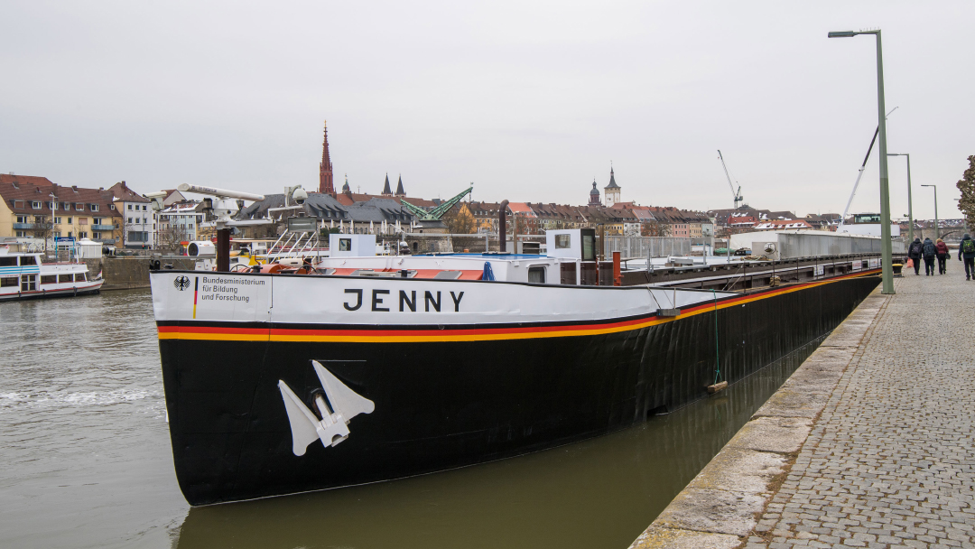
Captain LAESSI
© DLR CC-BY 3.0
How can cargo transport by vessel be made safer, more punctual and more cost-effective? With ships that berth and pass locks by themselves without needing a captain. DLR has been tackling this issue since 2008. The European Galileo satellite navigation system forms the basis for position determination, complemented by special correction data and current information about the waterway. The marine assistance systems LAESSI on board the vessel Jenny check whether the next bridge provides sufficient overhead clearance, the autopilot maintains the previously defined navigation channel, and the berthing assistant interlinks the position of the vessel with information on the environment in order to facilitate berthing. The next step are fully autonomous ships. DLR’s testbed on the Spree-Oder waterway offers ideal research conditions for this purpose. By 2030, cargo transport on inland vessels is supposed to increase by 23 per cent.
© in-innovative navigation GmbH, Alberding GmbH, DLR, WSV

Traffic jam information for the ocean
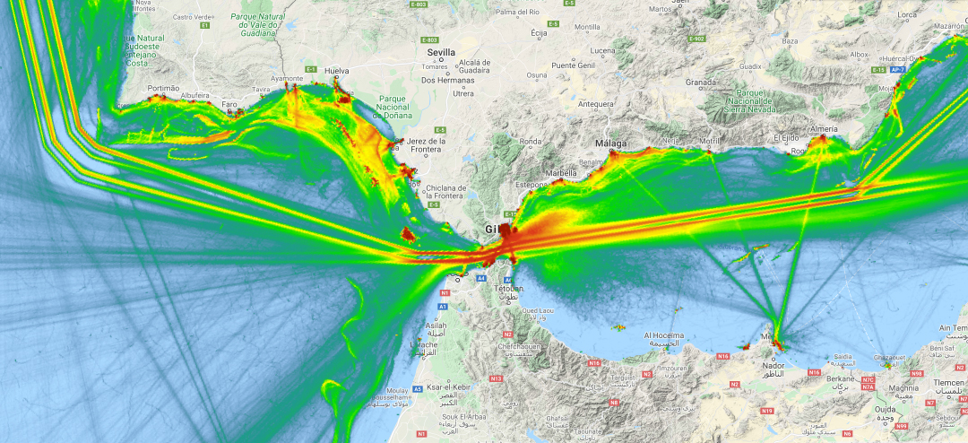
© EMODnet Human Activities Vessel Density Maps
(Live-Map: http://www.emodnet-humanactivities.eu/view-data.php, Vessel Density)
When traffic is jammed at the ocean and in ports, cargo will be delayed. The EMODnet project is the first to display congestion free of charge for everyone. In this way, better routes can be planned. The readings of AIS transponders with which vessels transmit their position data every second form the data base.
Knowing when the cargo container will arrive
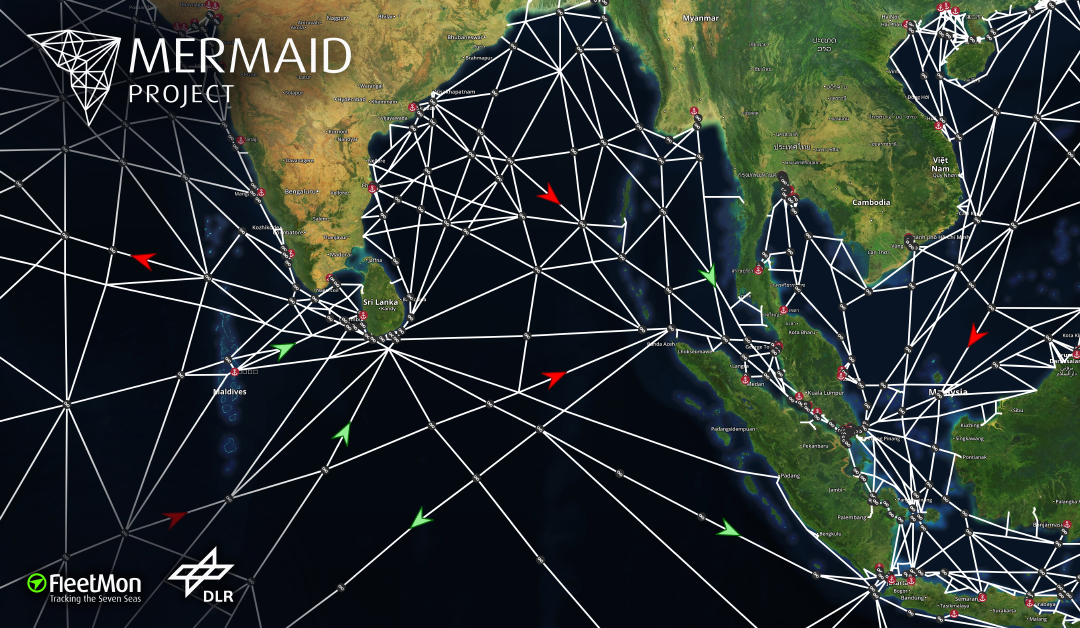
© FleetMon/DLR
Within the DLR’s MERMAID project, global ship tracking – based on AIS – is being developed that calculates the time of arrival of ships in the port. Besides the position, the weather and tide are also taken into consideration. The information is interesting for freight forwarders who can get reliable information as to when the container will arrive at the port. Knowing the exact time of arrival, port resources can be coordinated much better – and, finally, supply chains can be planned much better.
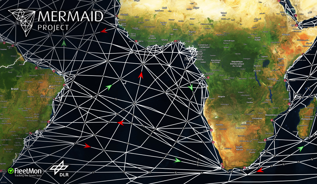
© FleetMon/DLR
Speeded-up customs clearance
© EMSA ABM 2018
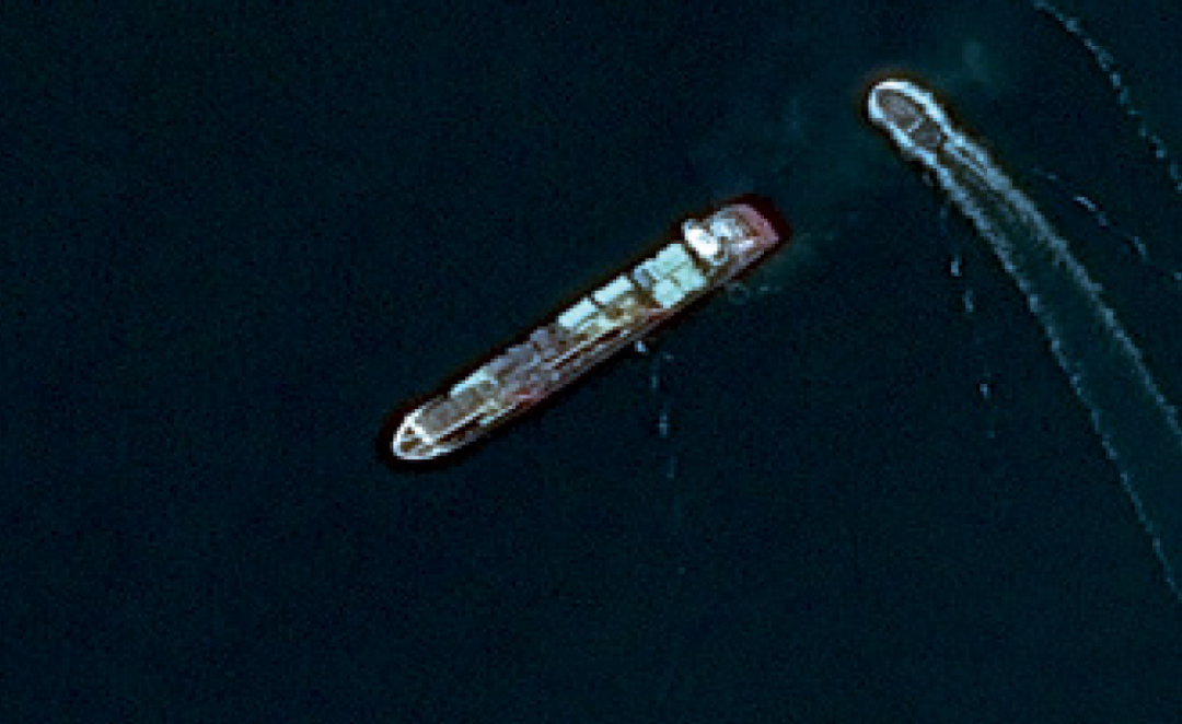
Customs clearance of vessels delays transport, partly by days. As soon as a vessel enters international waters, even if it only navigates from one EU country to another, the total cargo must undergo customs clearance. A single European transport area for shipping will change that. Planning to that effect is currently in progress. The end-to-end use of satellite technology is a basic prerequisite. Tracking of ships from space is already working thanks to satellite AIS. But what if criminal energy comes into play? How do customs know that a vessel did not get in contact with a second ship and smuggled goods have been transshipped? And both vessels could even have turned off their AIS transponders for deception! For this purpose, data from optical and radar satellite systems are required. A freely available software named SUMO which automatically recognises vessels on satellite images is already available. Since 2017, the European Copernicus Maritime Surveillance Service has been active which will enable many new services in the future, like, for example, the tracking of smugglers, and which will give honest captains the green light in customs clearance.
Algorithms preventing accidents
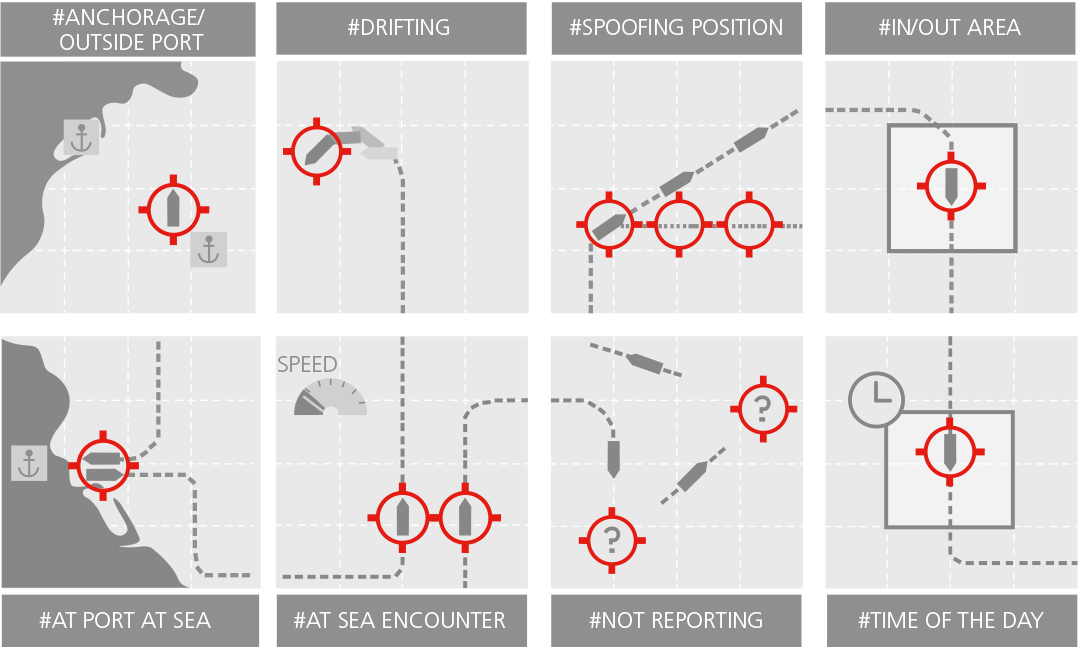
Origin: © EMSA ABM 2018
Movements of ships are mostly easily predictable since their speed is low and they rarely alter their course. EMSA, the European Maritime Safety Agency, has developed algorithms capable of detecting remarkably abnormal movement patterns of a ship – based on AIS data. The system gives an alarm when a ship comes too close to the shore, and when it is adrift or on a collision course with another ship. In this way, accidents can be prevented. In case a ship deactivates the AIS transponder, the software will get suspicious. In the future, a mix consisting of satellite technology, ground stations and algorithms will make maritime traffic safer and faster.
Help in an emergency
In the EMSec project, with DLR involved, satellite and AIS data are used in an emergency at sea to pilot aircraft with special onboard sensors to the right spot. This aircraft scans the situation and transmits images to the ground station. In this way, better coordination of a rescue mission can be achieved, either to help people or to fight off a natural disaster.

Vessel tracking from space
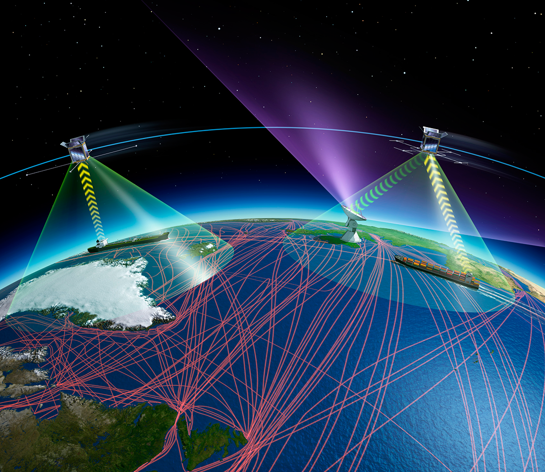
© ESA
Since the end of 2018, the company exactEarth has been offering worldwide real-time AIS, based on the data of about 60 satellites. The AIS receivers are on board the Iridium NEXT satellites. Every ship in the world equipped with an AIS transmitter is scanned at minute intervals. Even more suitable are own microsatellites that are specially optimised for AIS and thus deliver more reliable data – especially in highly busy marine areas. In autumn 2019, the AIS satellite ESAIL with a weight of only 110 kilogrammes, which will further develop SAT-AIS technology, was launched supported by ESA. It is part of the exactEarth service and thus the first commercial pure AIS satellite.
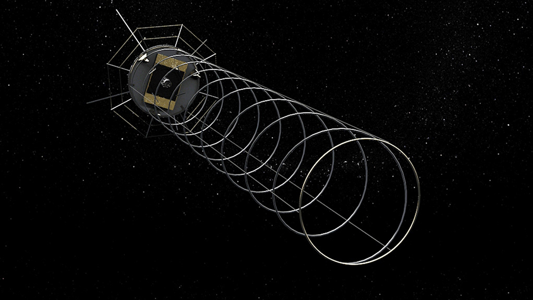
AISat-1: the German ship tracking satellite
The nanosatellite AISat-1, developed at the DLR Institute of Space Systems in Bremen, has been delivering important insights since 2014. It weighs 14 kilogrammes only, however, it is equipped with a 4-metre antenna in helix shape that unfolded no earlier than upon its arrival in space – a huge technical challenge that had been tested first during parabolic flights.
© DLR