More precision, more suitability for daily use: Galileo
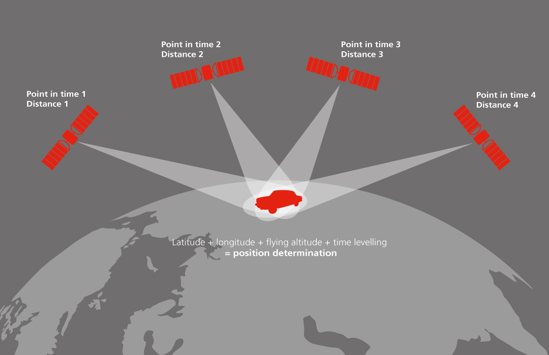
Today, satellite navigation is part of our everyday lives: almost every smartphone uses satellite signals to determine the position. The signals from four satellites are sufficient to exactly determine one’s own position. The US-American GPS was the first system, followed by the Russian GLONASS, and, since 2016, the first services of the European Galileo system have been in operation. The Chinese BeiDou is also available worldwide. As yet, Galileo reception has been integrated in approx. 1.5 billion devices, among them especially current smartphones from well-known brands. The particularly precise position determination by Galileo is used, for instance, for the eCall emergency call system that is integrated in an ever-increasing number of vehicles, and Galileo will support autonomously driving vehicles in the future.

© ESA
Galileo will be the only system under civil instead of military control. So the military cannot influence Galileo signals, which, however, is the case with other systems like, for example, GPS or GLONASS. A container ship entering a port automated and with a precision in the range of centimetres better should not have to rely on a system that might be subject to any such influence.
The greatest advantage of Galileo is its high precision of up to 1.5 metres. One can test the fascinating precision of Galileo by oneself, with the android app GNSS Compare. With dual-frequency receivers (Galileo transmits on two frequencies), precision in the range of 10–50 centimetres can be achieved. An ever-increasing number of smartphones are equipped with this technology. Based on the very good Galileo position data, many new location-based applications will emerge in the near future that will change our daily lives as well.
Quick accident assistance thanks to eCall
© European GNSS Agency
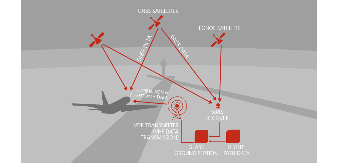
Since March 2018, all new car models in the EU must have “eCall” on board, the automatic emergency call system for accidents. In case of an accident, the system automatically makes an emergency call – of course, including position data and direction of travel. Thanks to the combination of Galileo and EGNOS the precision is so high that rescue workers know on which side of the road the vehicle involved in an accident actually is. From 2022, the technology will even be installed in all new smartphones in the EU, because the successor of the emergency call 112, E112, which automatically transmits the position in an emergency call, will then become operational.
Faster help in an emergency
© European GNSS Agency
In sequestered regions, it is not possible to dial 112 in case of an emergency. This is why Cospas-Sarsat has been existing since 1982, a satellite-based emergency call network that receives radio signals from emergency call transmitters and transmits them to control centres. The disadvantage: so far, an emergency call had a run time of up to four hours with the locating precision being at about ten kilometres. The system was significantly improved by the new SAR/Galileo service. Since the emergency signal is now located by the Galileo navigation signals, precision was improved to two kilometres. The new overall Cospas-Sarsat MEOSAT transmits the emergency call to a control centre within ten minutes – considerably improving rescue chances. In addition, those who make an emergency call get a feedback confirming the emergency call for the first time.
Autopilot in the car
© DLR
In the test field Lower Saxony, cars, buses and trucks are taught automated driving, supported by DLR. The most important element: the car must know where it currently is. This requires precise maps – and the knowledge about the exact position that can only be delivered by Galileo.
Many things are needed in addition such as crossroads with radar position determination and cameras, and traffic lights “telling“ the cars when they turn green. Tests are run in Braunschweig and on motorways. Safety is also an important issue and is researched in the joint Pegasus project. The
first application derived from this research, the automatic “motorway chauffeur“, is soon to go into series production. With this system (level 3 on the autonomous driving scale from 1 to 5), you can legally stop watching the road as if you were driving with a real chauffeur. And at the end of the drive? The car can find a parking spot on its own and park without a driver, for instance, supported by a drone that detects free parking spots from the air and allots them to the cars, which subsequently find the parking space on their own and park as if by magic. It works. DLR has developed and tested this system within the EU project AUTOPILOT.
Toll via satellite
Where is the money taken from with which motorways, bridges and tunnels are built and serviced? Either from tax money or from user fees – known as toll. In many European countries, toll depends on distances travelled. All systems are working in different ways: either with toll stations like in France or with position data via satellite like in Germany. The EU wants to make the systems compatible. The key: Galileo. Satellite technology is low-cost and, thanks to the high precision of Galileo, the systems can distinguish toll and toll-free roads better, if they are close to each other.
Road maps from space
© DLR
Thanks to Galileo, a car knows where it is – with a precision down to a few centimetres. This information can only be used meaningfully if the maps are that good, too. Mapping is expensive and would, for instance, require that all roads be newly mapped by LIDAR surveying vehicles. That takes time. Significantly less expensive: mapping from space, planned in the DLR project DriveMark®. With the help of the German satellites TerraSAR-X and TanDEM-X, maps featuring a precision of 20 centimetres become possible. And will there be a backup in case satellite navigation breaks down? Yes.
In addition, landmarks should help the vehicle to precisely determine its position. If the camera in the car detects a certain road sign, it takes the corresponding position data from the database and can thus synchronise the position.
The future of navigation
is being researched on in Germany
© DLR
© Anselm Daniel from the Institute for Railway Vehicles and Hoisting Technology (IFS) of RWTH Aachen
© DLR

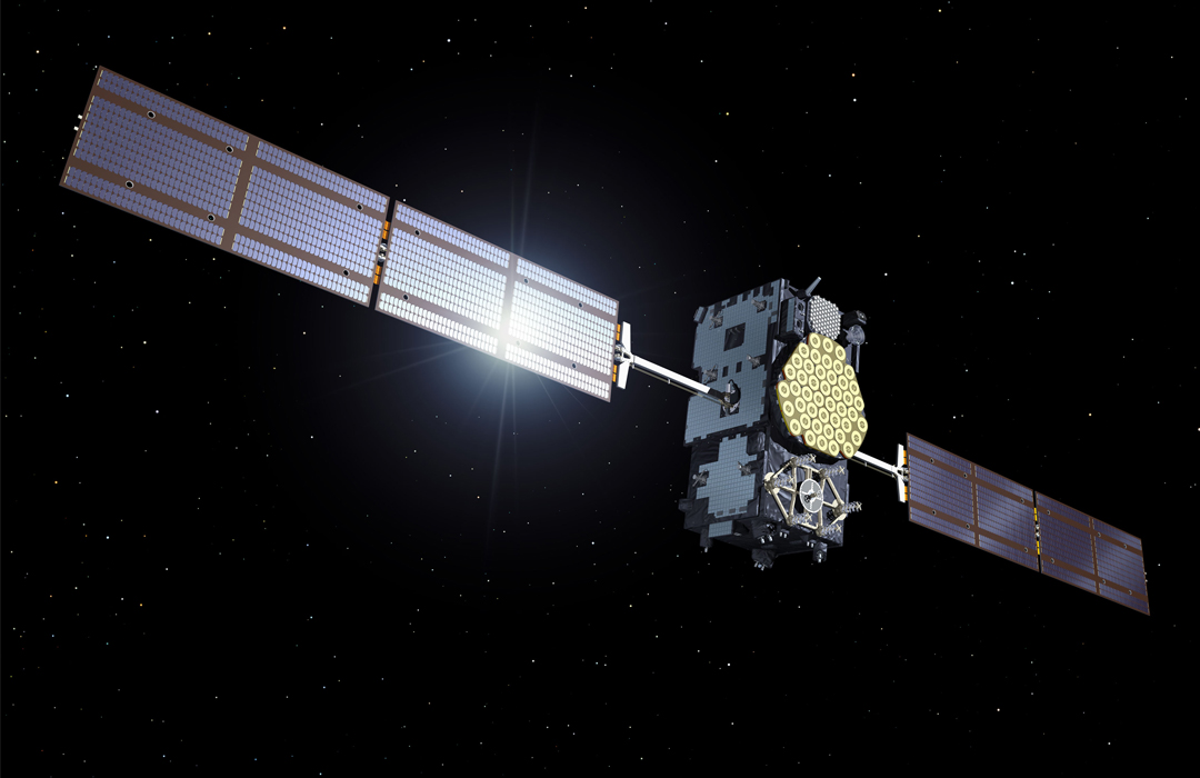
Galileo: European satellite navigation
featuring the precision of an atomic clock
© European GNSS Agency
For precise time measurement, the Galileo satellites are equipped with atomic clocks featuring a precision that would result in a deviation of one second only over a period of three million years. Jointly with each signal transmitted by one of the satellites to the receivers on Earth, the exact time of transmittal is sent with hitherto unprecedented precision. This is the only way to calculate the position of, say a vehicle, on Earth from the runtime of the signal as well as the satellite positions in space with such accuracy. The more precise the clock, the more accurate is precision determination. The Galileo satellites are controlled by the Control Centre of the DLR in Oberpfaffenhofen and from Fucino in Italy.
The Galileo services
Open Service (OS)
Similar to GPS and GLONASS, the Galileo data can be received by everyone free of charge – however, they are more accurate with a precision in position determination of 1.5 metres (when using a double-frequency receiver even 10‒50 centimetres). You can rely on this Galileo accuracy at any time since it is a public European system. Other systems are under the influence of the national military. In a conflict situation, the military would be able to artificially impair the accuracy of a system.
High Accuracy Service (HAS)
A free service complementing the Open Service. Accuracy is less than 20 centimetres.
Commercial Authentication Service (CAS)
A commercial service that enhances the accuracy of HAS by an additional encrypted authentication component.
Public Regulated Service (PRS)
A special service particularly for sovereign applications (police, fire fighters): the signals are highly precise, reliable, better protected against jammers, and encrypted.
Search And Rescue Service (SAR)/Galileo Service
This service cooperates with the Cospas-Sarsat MEOSAT system and allows for a fast and worldwide position determination of emergency call transmitters, however, for the first time also featuring a feedback channel from the rescue coordination centre to the sender of the emergency alarm.